This is my idea for three acres of contiguous open space. The land contains significant portions of e-zone with some meadowy settings. There was a sort of homestead house, now demolished.
This concept has not been discussed at Collins View Neighborhood Association meetings, but there is informal support for it.
John Miller
1/2015
The Property
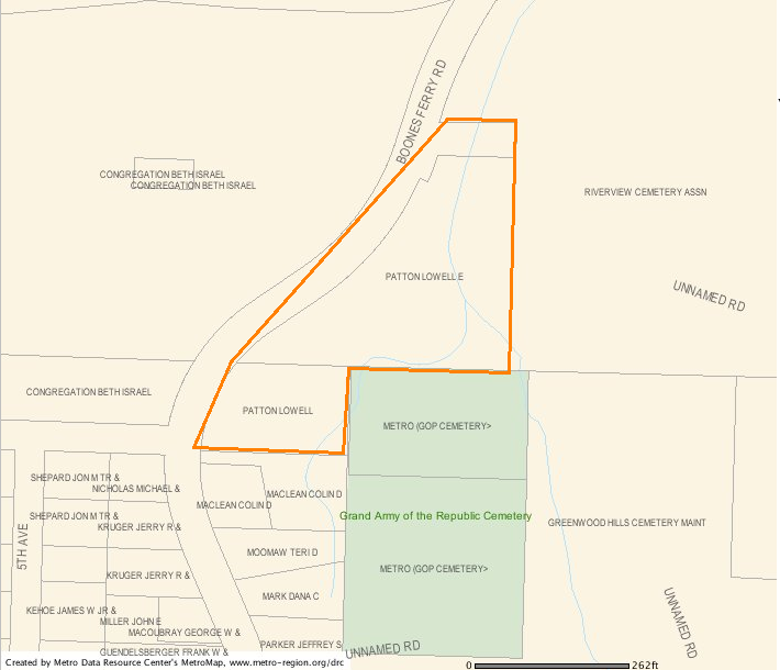
This property is near the intersection of
Boone's Ferry Road & Taylor's Ferry Road in Multnomah County.
The property consists of two parcels of land bounded by
Beth Israel Cemetery (across Boone's Ferry Road),
Riverview Cemetery,
the Grand Army of the Republic Cemetery (in the Greenwood Hills Cemetery),
and the Collins View neighborhood.
There is an adjacent small northern triangle of land (presumably) belonging to River View Cemetery that could be included. (Perhaps ~1 acre?) Some conservation efforts have been started.
The land is just north and west of property owned by Metro — an undeveloped part of the Grand Army of the Republic Cemetery (a Metro Historical Cemetery). It would be nice to combine that parcel into the nature park.
Aerial view
Historical and Geographic Context
Alfonso Boone, grandson of Daniel Boone, founded the Boone's Ferry in 1847. The ferry crossed the Willamette at present-day Wilsonville, where the river runs west to east.
[Interpretive PDF]
You can also see good a Wikipedia article on Boones Ferry.
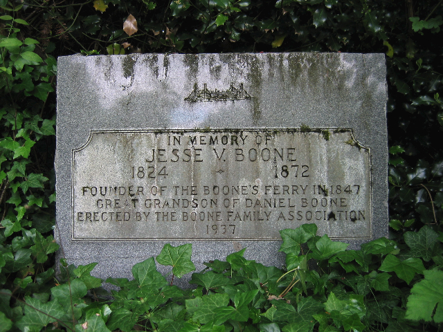
Jesse Boone (Alfonso's eldest son, Daniel's Great Grandson) cleared the Boone's Ferry Road and operated the ferry until his (early) demise in 1872.
Boone's Ferry Road is one of the oldest roads in the region, extending away from the ferry north toward Portland and south to Salem.
The northern terminus of Boone's Ferry Road merges with and becomes Taylors Ferry Road as they both head downhill to SW Macadam Road, along the Willamette River, losing ~400' elevation.
A historical marker was placed at the north end by the Boone Family, and dedicated on October 24, 1937. (will have the speech here soon.)
It's not a gravestone, it's a historical marker. Jesse is buried in the Butteville Cemetery, near Butteville Oregon — couple miles from the Boone's Ferry Landing on the Willamette River, close to Wilsonville.
The monument bears a resemblance of the original ferry.
This property is just south of the northern terminus of Boone's Ferry Road, on the east side of the road.
A house (possibly related to the toll road) was located at the north end of the property, about 75 yards south of the historical marker.
The Property Owner
The current owner of the proposed natural area is Mr Lowell Patton, of Carver, Oregon.
Mr Patton knew the previous owner or renter of the Boone homestead house.
Mr Patton bought the property to help this person out,
and then held onto it after the person moved away.
The house became derelict, so the City required it to be demolished sometime in the 1970's.
Mr Patton demolished it.
Perhaps Lowell could accurately point out the location, or there are photos of the house somewhere in the Boone Family. There could be some trace of the homestead under the vegetation.
Mr Patton hoped to build a convalescent center on the property in the 1980-90s, but nothing materialized.
He requested that the property rezoned in 1998 when the Southwest Portland Community plan was done.
(Actually, I think the parcels were mistakenly zoned OS, due to their proximity to cemeteries. That was corrected to R10 and R7 at that time. Dave Johnston, CVNA Landuse chair has been asked to clarify this point.)
In 2005,
Mr Patton filed Measure 37 Claim #PR05-138016 for $1,380,000 as compensation for not being able to develop the maximum number of housing units by filling in the entire (riparian) area.
Patton's claim was denied by the Portland City Council on November 30, 2005.
It appears that Mr Patton may have no future plans for the property and may be a willing seller.
(
Notes:
Alternate M37 Claim number: M118611.
The screen shot below is now out of date.
)
property tax lots
Recent History
190?-1974 - The Homestead or Boone House.
1993 - Traffic Diversion installed, partially closing Boone's Ferry Road as part of a Neighborhood Traffic Management Program.
1998 - The Zoning was reviewed but not changed.
2005 - A Measure 37 Claim was filed by Lowell Patton in July, 2005.
2005 - The M37 Claim was denied by City Council in November 2005.
2015 - A developer representing Mr Patton requested a hearing with city bureaus regarding what would need to be done to develop the property. The hearing was on Oct 29, 2015. Collins View Land Use co-chairs (Johnstons), CVNA president (Jim Diamond), and I attended to listen. Nothing was built due to reduction of land for buildable sites.
Nature
Coyotes can be heard howling from this area.
Sirens from nearby Engine No.10 often set them off.
A small forked creek runs through the land, with some of it being quite wet.
This is a south fork of Stephens Creek.
The creek drains down along Taylor's Ferry road, crossing under Macadam, and flowing into the Willamette at (Butterfly Park?)
Some group seems to be taking care of the ravine. Ivy has been pulled, and there is some replanting going on. I don't know who. JM 1/2015.
In the ravine, down hill from the property, probably on River View Cemetery property,
is an old dump (from 1940's?) that could be cleaned up.
IMAGE caption
How can this place be characterized, biologically?