What is The Trolley Project, and How Did it Get Started?
This is the story of how we got involved in researching the Metropolitan Railway Company’s F Line trolley through our neighborhood. While we were researching the F Line, we also learned a great deal about other trolleys, interurbans, and railroads that served the area south of the Portland city limits during the late-19th and early-20th centuries. We’ve included such information, along with other historical findings and ideas for future projects, elsewhere on the website.
A Street Car Went Right Through Your Yard!
In October 1978, I bought a house on Boone's Ferry Road just north of the entrance to Greenwood Hills Cemetery. My next door neighbor Doris Graham told me: Why John, a street car went right through your yard! I thought yeah right, this old lady is off her rocker. Doris also said that my old garage had been a blacksmith shop. Over time, I came to believe Doris about the blacksmith shop because I found plenty of evidence in the earth and stuff otherwise left behind. But I just filed the street car story in the back of my mind. In hindsight, I wish I'd had the wits to ask Doris to tell me more about this streetcar.. and that I could have interviewed Mary Fürher or Robert Johnson on Primrose who were probably old enough to have seen the Trolley. Alas, I did not.
In April, 2013, Greenwood Hills Cemetery newsletter included an article on how trolleys came to cemeteries in Southwest Portland!
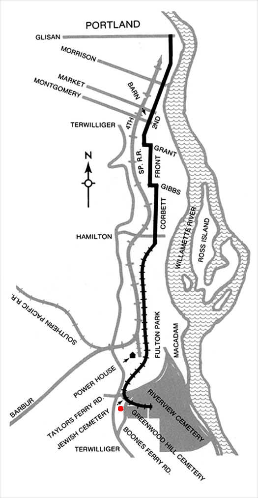
The newsletter article had a map that seemed to confirm Doris's exclamation.
Metropolitan Railway Route Map [Labbe,p72]. Schematic Map by Alexander B. Ceres
The Greenwood Hills newsletter article was based on info in the book
Fares, Please! Those Portland Trolley Years by John T Labbe.
The added RED DOT is my ~1914 house. This map is correct in most ways, but the southern end of it is not quite right. We discuss this map on the Maps of Interest page. (That page may change).
These web pages are inspired by that newsletter article, the Labbe book, Internet finds, and amateur sleuthing on the ground. A few people know generally about this Trolley Line but many details have been lost to history.
The 2020-21 Trolley Project
The COVID-19 Pandemic forced us to stay at home, not travel or do other normal things.
At some point, I decided to follow up on the Greenwood Hills Cemetery newsletter article.
I thought it would be easy to learn the full story of the trolley that went through my property. So, I picked up a copy of Labbe's book via an Amazon re-seller.
On Dec 12, 2020 — John posted the above story on Facebook, and got a LONG thread of responses.
Tony Paolucci, a map collector friend, jumped in with some great map finds and interpretations.
Over Christmas, we checked Richard Thompson's Portland Street Cars books out of the library, visited Thompson's website, and other local history websites. As we waded into these sources we found them contradictory and found that solid information on the Fulton-Park-Cemeteries line was scarce. And so began many hours of re-parsing descriptions of the trolley line, and trying to trace the ground where the trolley may have gone.
In addition to our online and book research, we started doing reconnaissance by foot and by car, looking for physical evidence of the F Line.
At first our explorations were guided by some misconceptions, principally
that the trolley came most of the way out to Fulton Park on Corbett Ave, including up the Corbett ramp.
So we wasted a lot of time exploring the John’s Landing area, looking for evidence of tracks on Corbett and trying to figure out how it could have crossed the Stephens Creek ravine from Corbett.
Our big breakthrough
was a newspaper article from Dec. 30, 1899, describing a first ride on the new Metropolitan line to the Fulton Park powerhouse.
That article re-focused our explorations on a different alignment for the F Line, higher on the hillside.
We started taking field trips to examine the territory between downtown and Fulton Park.
In particular, we investigated where the trolley left Corbett and went onto its own trestle along the hillside;
a neglected sliver of land between Slavin Road and I-5;
under and over the Newbury/Iowa and Vermont trestles along Barbur and I-5;
and along a very intriguing trench north of SW Brier Place
that is likely the route the trolley took into Fulton Park.
Plus, we scoured the Fulton Park area for the site of the powerhouse.
We did similar recon examining the topography between Fulton Park and Carson Heights, through our neighborhood, and within Greenwood Hills and River View Cemeteries — trying to think like a trolley, or at least like a surveyor: follow the contours of the land and, if you can’t, build a trestle or dig a trench! All the while we had to try to see past modern highway construction, sewer projects, changed street names, and other urban development.
At some point we learned that the later Oregon Electric to Multnomah was built in the F Line’s right-of-way, with I-5 following in that corridor. That gave us more modern evidence to look for but it also dashed a lot of our hopes of finding artifacts of the F Line — because much of the route lay under I-5 or had been otherwise obliterated by the 1960-61 construction. We were able to develop a general sense of the route based on terrain and the trajectory of the Oregon Electric (whose traces can be seen in old aerial photographs). And we had certain touchstones along the route to refer to: the existing I-5 and Barbur trestles at Iowa* and Vermont, the alignment of the railroad and interurban line (now Barbur Boulevard) that also went to Fulton Park, some old piers and retaining walls, and the trenches (cuts) we'd discovered on the west side of I-5. But most of our evidence has had to be gleaned from old maps, photographs, and drawings.
*For reasons unknown, the viaduct on Barbur corresponding to Iowa is called the Newbury Viaduct.
In the process, John wrote emails to a few neighborhood leaders and elders asking what they knew.
Two cartographers got interested in the quest - Erik G, and Matthew H,
And we were introduced to Stephen Dudley who has encyclopedic knowledge of local rail history.
As a group, we have combed newspaper and city archives, the library, various blogs,
Oregon Historical Society, and the Oregon Department of Transportation; we've also been in touch with the Portland Bureau of Environmental Services, River View Cemetery, Greenwood Hills Cemetery, Beth Israel Cemetery, and River View Abbey.
John sent out ~60 postcards to houses that are near the trolley tracks, hoping to get any leads, and to inform people about our project.
Maybe we will find 'The Blueprints', or a number of different maps and plans that will tell the whole story, but we think we have a pretty good start here. We also have ideas for some well-defined smaller projects.
On the F Line page, you'll find questions we're hoping to answer in order to complete the Trolley Stories.