This is a “Sidetracks” feature written for the Trolley Project website.
For a basic understanding of the trolleys that served SW Portland, please go to: dialectrix.com/trolley.
This is a “Sidetracks” feature written for the Trolley Project website.
For a basic understanding of the trolleys that served SW Portland, please go to: dialectrix.com/trolley.
The Metropolitan Railway Co (MRC) electric trolley came out from downtown to Fulton Park, then traversed Carson Heights, crossed Taylors Ferry Road and ran along the western edge of Beth Israel Cemetery. When the trolley was being built, it ran only as far as the edge of the cemetery for a few days or weeks.. People got off and walked "a stone's throw" to the other cemeteries. Here is an account from the Morning Oregonian, Saturday, May 30, 1891:
"The track of the Metropolitan Street Railway Company has been extended out to the Hebrew Cemetery and the cars will be running out there today for the accommodation of persons wishing to visit the cemeteries. They will land passengers within a stone's throw of the Masonic cemetery and only a short distance from the western boundary of Riverview (sic), and persons going out this way will be saved the long walk up the hill in the cemetery."
End quote, from Morning Oregonian, Saturday, May 30, 1891
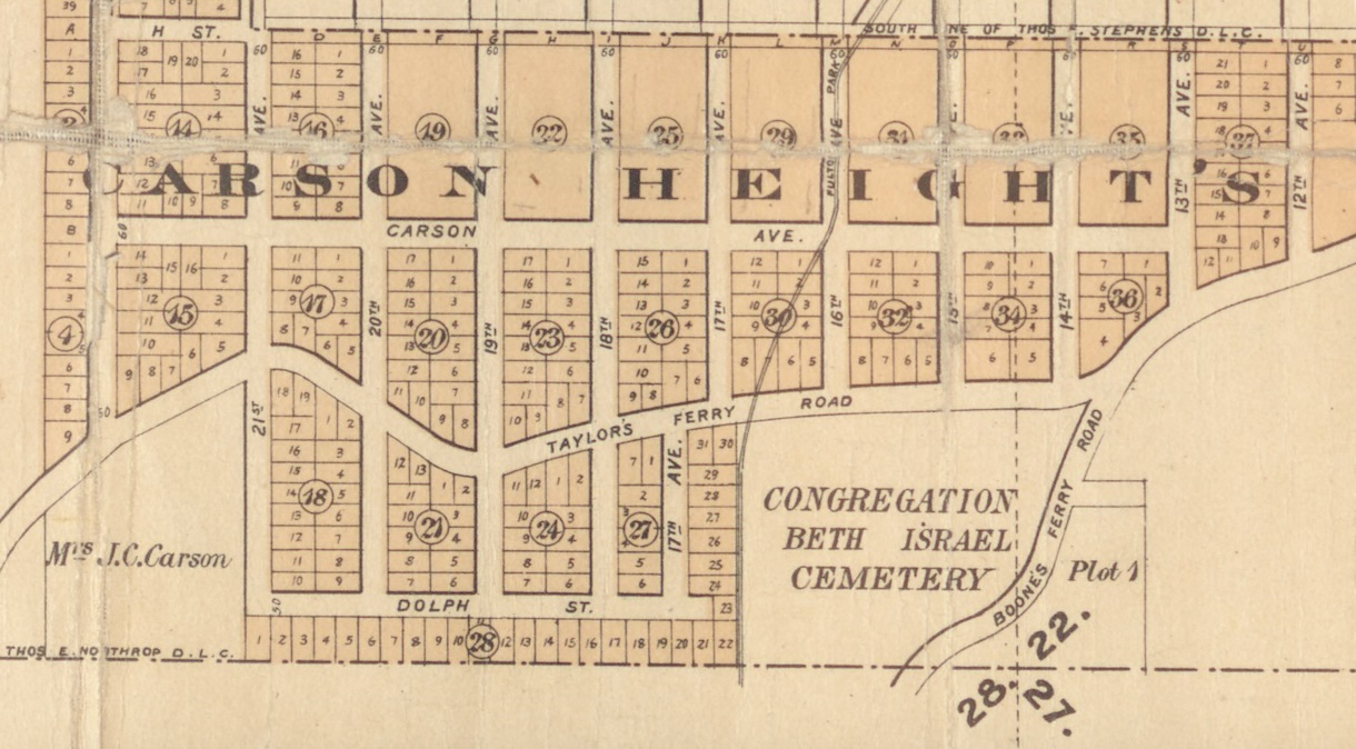
The above Map shows the trolley line (labelled Fulton Park Electric Trolley) at the western edge of Beth Israel Cemetery. The map is contained in Lewis & Dryden's 1893 Atlas of Portland and Vicinity. We accessed the atlas at the Multnomah County archive facility.
The trolley went as far as Beth Israel in May 1891, but was extended to other cemeteries in June.
The line was designed to transport visitors to three cemeteries in the area, Beth Israel, Greenwood Hills, and River View. At the time, Greenwood Hills Cemetery was a Masonic Cemetery established around 1882, Beth Israel Cemetery having been established ten years earlier.
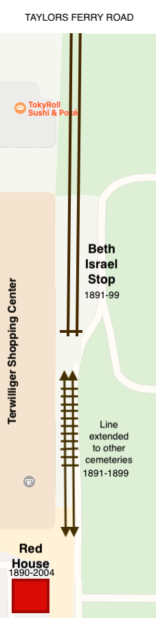
In the past, there was a Red House located where south of modern day Tryon Creek Grill, in the parking lot area. See the Teriwillger Center history in 'References' for background.
A man who worked on the trolley built the house, and lived there. The trolley could stop in the cemetery next to the Red House. The house had a veranda on the east side so that that trolley-man could just step onto or off of the trolley.
We have a copy of an 1891 agreement between MRC & CBI, recorded with Multnomah County. The agreement lists 7 conditions agreed to between MRC and CBI corporate officers (S. Blumaeur, President, and S.L. Wiener, Secretary). The agreement details the location of the right of way and provisions such as providing Funeral Cars, fencing, moving a water tank, and provision of electricity to operate a water pump at the cemetery. The seven terms are given below in plain english.
Here is the full text of original language of the 1890 Right of Way Deed from Congregation Beth Israel to Metropolitan Railway Company, along with a scan of the source document. [PDF]
We still have questions, like