A little-noticed manmade feature in our neighborhood offers an intriguing confluence of 19th-century trolley history and the modern-day sewage system. And if the so-called Brier Place Trench is preserved, it may one day provide a historical trail and overlook.
The trench, shown here in green, is located between Barbur Blvd and the I-5 freeway:
Brier Place Trench location marked in green on modern Apple Map
The street, Brier Place, is a developed, paved, portion of the trench at this altitude.
We think the F Line approached Fulton Park through a man-made trench, or 'cut', aligned with what is now SW Brier Place.
It is believed that the Brier Place Trench was dug in 1889 for the tracks of the Metropolitan Railway Company (MRC) electric trolley.
Portlanders and visitors rode the MRC through this trench for about ten years, beginning January 1, 1890.
The location of the trench fits The Morning Oregonian account of the Metropolitan's first run, in which the writer described the route to the powerhouse as 'a little below the O&C line' (now Barbur Blvd). The man-made trench is clearly visible on LIDAR image below.
LIDAR imagery for Brier Place Trench
See Thin vertical purple line in upper right of image.
LIDAR imagery for Brier Place Trench
Could this just be the result of digging a sewer line in 1925? We don't think so.
Side note: The thin horizontal purple line indicates a trench that aligns with SW Miles street - for reasons unknown, probably predating I-5! You can see it in person if you go to SW Miles & Brier Place.
Any northern portions of this hillside cut would have been obliterated by I-5. Since this was written, we have identified (on foot) what looks like a small surviving segment of this trench below Slavin Road. See that image in the LIDAR section of our Resource Collection.
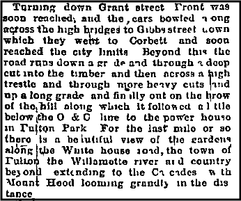
A Reporter's account of the inaugural trip through the trench
Here is the Morning Oregonian account of the inaugural run of the Metropolitan, made on Wednesday, January 1, 1890:
Oregonian account of passing through trench (legible text below!)
For easier reading, here is a transcription:
"Turning down Grant street, Front was soon reached, and the cars bowled across the high bridges to Gibbs street, down which they went to Corbett, and soon reached the city limits. Beyond this (the present S.W. Hamilton street) the road runs down a grade and through a deep cut into the timber, and then across a high trestle and through many more heavy cuts, and up a long grade, and finally out on the brow of the hill, along which it follows a little below the O&C line, to the power house in Fulton Park. For the last mile or so there is a beautiful view of the gardens along the White House road, the town of Fulton, the Willamette river and country beyond, extending to the Cascades, with Mt. Hood looming grandly in the distance."
Modern Day snooping around
While researching how an electric trolley could have arrived in Greenwood Hills Cemetery, we pieced together old maps, historic accounts, etc. We snooped around a lot. Through a process of elimination, we focused on the strip of land between the freeway and Barbur Blvd. Google Street View showed that SW Brier Place seemed to continue into the wilderness, so we checked it out on foot. After a moment I realized we were looking into the past. Simply put, it was breathtaking. Date: January 3, 2021. —JM
Astonishing Google StreetView image of the Brier Place Trench, where the F-Line likely came up into Fulton Park.
You can imagine the track and trolley coming through... this is so cool, you must see it in person. Go to Fulton Park, walk over the Brier Place toward Barbur Blvd, then take the spur north, also named SW Brier Place. Go to the dead end and stand there in awe.
You can bushwhack to the end of the trail, overlooking I-5, with a view of Mount Hood. It's an incredible place, unknown to just about everyone in SW Portland, with the exception of some homeless folks, and illegal dumpers.
Going down through the Trench?
If you go...
The Trench is a continuation of SW Brier Place, northward, alongside Barbur Blvd.
To view the trench, walk, bus, or drive to the Fulton Park School on SW Miles. Walk on SW Brier Place toward Barbur. At Barbur, Brier Place turns north. Keep on walking down hill.
There is No Parking for you on SW Brier Place.
Please don't disturb the residents by driving down this Dead End road.
This is not a developed trail.
We do not recommend that anyone venture into the trench who is not comfortable bushwhacking, crawling under over straddling a log, and so on.
The Trench may be variously littered.
In the summer you might encounter a "camper" at the end of the trench.
The Trolley Project assumes no responsibility for your safety. Enter at your own risk.
The trench is really cool!
If you do go to Fulton Park you can also admire two houses that existed when the trolley passed through. One house was built down along the trench, back in the day. The paved portion has six houses of various ages. 7010 SW Brier Pl was built in 1890! Over toward the school, 85 SW Miles was likewise built in 1890.
If you Really do go...
Be advised,
as you start down through the trench on foot, you may encounter various items that have been thrown off Barbur Blvd, which is just above the trench — for example a tire, or a discarded sofa bed.
Nice Sofa for Lounging, anyone?
Moving further along, we find -- A Modern Sewer??
Not very far along, you will come to a sewer manhole cover.
Manhole Number XXX? Photo Jan 8, 2021
What?
The Trench lay quietly for a quarter century, when in 1925 a city sewer project capitalized on the existing trench, likely disturbing any rail bed material (ballast).
We think the sewer folks took advantage of the abandoned Metropolitan trolley line. A written report likely does not exist (we asked), but we do have the 95-year-old plans for the sewer!
The 95-year-old plans for the sewer have very little info
No records of the actual sewer construction project remain, other than the obligatory line drawings of sewer cross-sections, etc.
This particular sewer line is scheduled for maintenance (re-lining) Summer 2024. See FUTURE below.
At the End of the Trench
The trench abruptly ends in thin air, probably where a trestle connected to the other side of the Vermont ravine... I-5 has altered the landscape. In fact, the Metropolitan right-of-way was used by a later electric railroad, and then essentially obliterated by I-5. Progress marches on.
At this point, the sewer line goes steeply down into the Vermont ravine, to join a main sewer line that was buried by I-5. A stormwater pipe line also goes down the ravine
and under I-5. (To protect I-5!)
Overlooking I-5 — and Mount Hood
Imagine..
It is really amazing to stand at this point, overlooking I-5 and Mount Hood.
Imagine electric trolley riders in 1890's taking in this view!
From the end of the Trench one can see the EXIT sign on I-5 for Lewis & Clark College.
Also from here one can see Barbur Blvd going over the Vermont Viaduct. This is similar to the IOWA (Newbury) viaduct that SW Trails #5 passes under (further north on Barbur).
Looking up at Barbur going over the Vermont Viaduct
Unfortunately, this place has been a homeless camp for years, with layers of detritus.
"Campers" can scramble down from Barbur to the viewpoint (rather than coming down through the trench).
Sometimes there is a camper under the bridge.
Note shopping carts in the ivy.
Update: This site and the trench has been mostly cleaned, perhaps as a result of recent survey work by the city. Hopefully more restoration can be done by volunteers.
Beyond the trench, one can bush whack down into ravine. But beware of ivy-covered old wire fencing of the type used all along I-5 in the 1950's. This is not at all recommended! If you go down into and work your way up through the ravine, you'd come up at the SASQUATCH VIEWING AREA on Terwilliger Blvd. So watch out!
The FUTURE -- in progress
A new SW Trail? A down & back trail to the viewpoint would be a pretty easy project. A loop down the trench into the ravine and up to Terwilliger Blvd would be cool, but fairly ambitious. It would complement the existing SW Trails system... imagine being able to walk from Fulton Park (eg SW Trail #5) down the through the trench and up the ravine to Terwilliger at Nebraska -- without crossing Barbur or a single stop sign!
A simple 'Trolley Trench' path (down and back up) could be a side trip, part of a multi-mile 'Trolley Walk' retracing the MRC and N-S Lines.
CIPP - The Cured-in-Place Pipe lining technology
[LINK]
This link will take you to a page showing info about the specific sewer pipe. Good Luck!
[LINK]
Exercise
When driving I-5 South, before the curve, before the Terwilliger Exit, look up to the right. The trench is up there. It begins its ascent right at the bridge there. It's below and to your right when traveling north on Barbur Blvd, past the light at SW 3rd & Miles (and SW Brier Pl). Imagine it. See map.
Please Honor our Creative Commons License
Whereas
we've worked hard to gather the information presented here; and
we've added value with our original writing;
we are placing this page under a Creative Commons Attribution 4.0 International license
[CC BY-NC-SA 4.0].
All we ask is notification and attribution of any re-use.
Please send notifications to trolley @ Dialectrix.com — Thank You!