This is a “Sidetracks” feature written for the Trolley Project website.
For a basic understanding of the trolleys that served SW Portland, please go to: dialectrix.com/trolley.
This is a “Sidetracks” feature written for the Trolley Project website.
For a basic understanding of the trolleys that served SW Portland, please go to: dialectrix.com/trolley.
From 1890 to 1933, three different electric rail lines crossed the Corbett Gulch just south of SW Seymour Street, where Slavin Road once met Corbett Avenue. The Metropolitan (FP Line), the Oregon Electric Railway, and the City & Suburban Fulton Line each followed a different route across the the deep ravine. But with no trace of the trestles left, the location and trajectory of each line has been an ongoing puzzle for us. We’ve stood on the existing bridge over I-5 and speculated endlessly, our imaginations hampered by the carving-out of the freeway, which changed not only the shape of the gulch but the orientation of the Corbett bridge.

Looking down from the Corbett overpass today, it’s hard to reconcile the expanse and the noise of the freeway with the wildness of the “deep gulch” that challenged road and rail engineers at the end of the 19th century. Now, after decades of filling, excavating, and leveling, the shape and depth of the original Corbett Gulch is forgotten. But with the help of a few old maps and photos, we’ve been able to make some guesses about how the three sets of tracks crossed the gulch. The first Corbett traffic bridge, which also carried the City & Suburban trolley, would have crossed about where the shadows of the power lines are in the above photo. The Oregon Electric trestle would have roughly angled away from the bridge to the southwest from that bridge and made landfall at about the Corbett exit from I-5 northbound (bare spot at center). The oldest crossing, by the Metropolitan, is the hardest to pin down, but we think it left Corbett around Slavin Road (on the hillside to the right) and curved over the gulch, continuing on in the I-5 alignment.
On pre-1900 maps, Corbett Street ends at Seymour Street. Wagon and pedestrian traffic to the Fulton and Fulton Park communities must have used Macadam Avenue, and Corbett itself wasn’t extended south into what is now John’s Landing until 1901, when City & Suburban Railway began to run its new Fulton line along Corbett to River View Cemetery. This means that the Metropolitan’s trestle was most likely the first structure to span Corbett Gulch.
An 1889 newspaper account is the only reference we’ve seen to the construction of that trestle:
The work of raising the trestle over the gulch at the end of Corbett street on the electric motor line of the Metropolitan Railway Company was begun yesterday. The trestles on the line are to be the most substantial in the state, the ties being of extra size and laid within half an inch of each other. (Morning Oregonian, June 8, 1889)
The largely undeveloped area of “Southern Portland” was still outside the city limits at this time, and therefore not well mapped. But even the few existing maps differ in their depictions of how the FP Line crossed the gulch.
As we indicated in the FP Line section, the 1893 Lewis & Dryden map below may be the most accurate of the several we’ve seen. All the maps show the Metropolitan route across the gulch to be curved, though that curve and the next one to the south are probably exaggerated on this map.
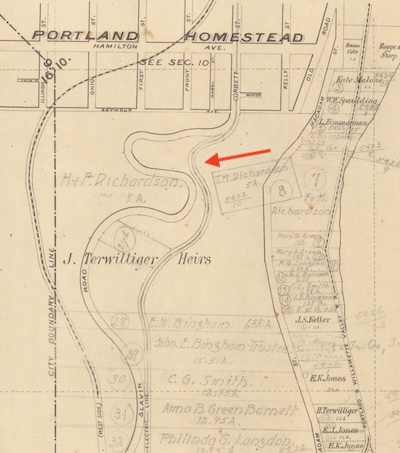
We think the trolley may have shared a short stretch of Slavin Road before angling west and onto its trestle. In 1889 the Metropolitan Railway Company requested a 330' right-of-way along Slavin, but we don’t know if it was approved. (See the document in the Resource Collection. Link: [JPG scan].)
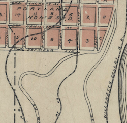
Other maps from the time represent the crossing differently. This detail of an 1891 city map shows the trolley leaving Corbett where it intersects with Slavin Road. (Note: Slavin Road no longer connects directly with Corbett, instead joining Seymour Street a short distance to the west.)
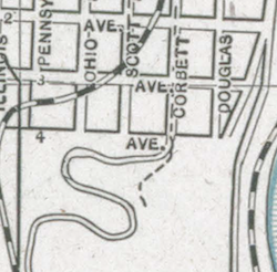
This segment of an 1892 street renaming map, has the trolley shooting off directly south from Corbett. (Note that the E-W streets were numbered 1st through 4th before the renaming, with 4th becoming Seymour.)
In all three maps, two other features are notable. Serpentine Slavin Road was already a popular commercial and scenic route that wound through the hills and forest to the farms of Hillsdale and beyond; the section of Slavin west of Barbur Boulevard is now called Capitol Highway. West of Slavin on the maps, one can see a rail line in addition to the FP Line. This was the Oregon & California Railroad (later the Southern Pacific, which in 1914 began to run the Red Electric passenger trains along this route). The SP tracks were abandoned in 1929 and much of the route through SW Portland became Barbur Boulevard.
When the City & Suburban Railway began leasing the FP Line’s right-of-way in 1897, they already had an eye on a new route to the cemeteries at a lower elevation. By then the city limits had moved south, and when the C&S purchased the old Fulton right-of-way near the end of 1900, the city had already given the go-ahead to the proposed line along Corbett to the community of Fulton and up Taylors Ferry Road to River View Cemetery. This apparently afforded the city the opportunity to extend Corbett Street over the gulch.
While The Oregonian documented progress on this extension, including the beginning of survey work in January 1900, we have no record of the actual construction of the bridge across Corbett Gulch. We do have a 1901 map showing the streetcar route going across the gulch on a bridge that is in the same orientation as the road bridge that existed until the I-5 overpass was built slightly to the east around 1960.

Neither do we have photographs of a Fulton streetcar on the bridge, though there were plenty taken both north and south of the gulch. The only photo we have of the Corbett bridge (see next section) shows it peeking out from behind the Oregon Electric trestle. We can only assume that the alignment of Corbett before I-5 is the route the Fulton car took over the gulch on into the 1930s.
This assumption is somewhat challenged by a 1912 newspaper report describing a “large fill across a gulch at Seymore [sic] and Corbett streets.” (Morning Oregonian, June 2, 1912) The article went on to say, “the car tracks of the Fulton line are being transferred from a bridge to the ground, making travel much safer than before.” We can’t even begin to envision this, and without any photos or maps to corroborate the article, we believe the Fulton line must have continued to operate on at least part of the road bridge, including after the trolley was replaced by a trolley bus.
We do have both photographic and cartographic evidence of how the Oregon Electric Railway crossed the Corbett Gulch starting in 1907. And since the OE used some of the Metropolitan right-of-way, we can work backward to make some guesses about that first trestle. One big difference is that the OE approached the Corbett Gulch from downtown not on Corbett like the Metropolitan but from the northeast in the current I-5 alignment. It crossed Corbett at grade and was carried over the gulch on a trestle next to the Corbett traffic bridge. This map segment shows the OE route in 1928, as it crosses Corbett, on which the Fulton streetcar tracks are visible:

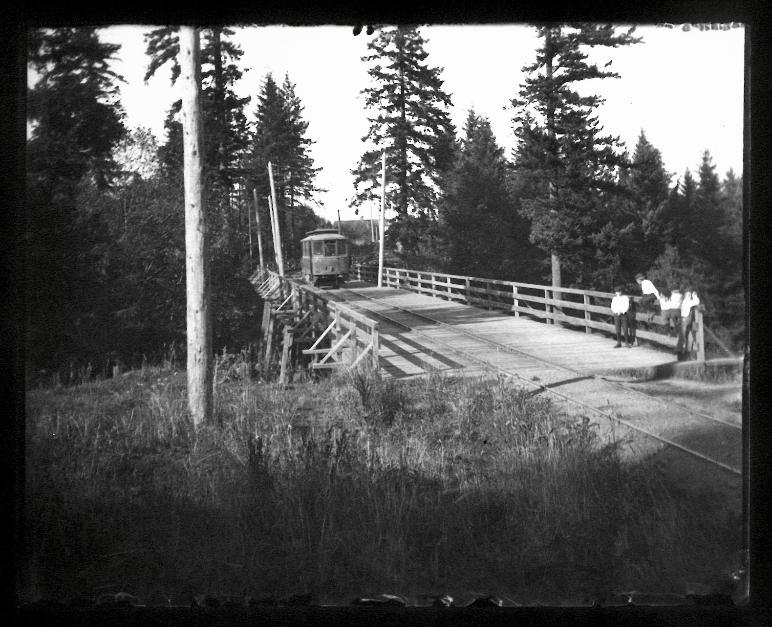
The only known photograph of the OE trestle over the Corbett Gulch was taken ~1910 by Fred Kiser, who was hired to document the construction of the Oregon Electric. The OE trestle is in the foreground, and visible through the vertical posts just to the east are the diagonal braces of the Corbett bridge. While Corbett went downhill into what is now the John’s Landing area, the OE stayed high on the hillside. And we think the FP Line had hugged the slope in the foreground, crossing the gulch a little farther to the right (west). But we also know that the north and south edges and general contours of the gulch have changed through the years, due to both fills and the excavation for the freeway, and could even be different in this photo than when the Metropolitan crossed.

The 1909 Sanborn Fire Insurance map shows the OE’s “wooden trestle” making a straight shot to the southwest from Corbett, unlike the Metropolitan’s trestle that we believe left Corbett farther north and curved over the gulch.

The OE crossed the next ravine on a longer curved trestle between current Richardson and Boundary streets, using the established Metropolitan right-of-way but building a sturdier trestle. Remnants of this OE trestle are visible in aerial photographs up until the mid-1940s, well after the tracks were abandoned in 1933.
The following aerial photographs from 1939 and 1960 tell a big part of the Corbett Gulch story. In 1939 one could still see the long curved trestle, as well as the way the OE crossed Corbett and then angled off across the gulch to the southwest.

By 1960, I-5 had obliterated everything. At the Corbett Gulch, the orientation of the Corbett overpass shifted to the east and Slavin Road made room for the freeway by curving up to Seymour, no longer intersecting with Corbett. Where the long curved OE trestle had been, two half-blocks of houses were replaced by a massive concrete wall on top of which the freeway now passes over the ravine. All these changes make it very difficult to establish the lay of the land, especially the way it was in the 1890s.

Not surprisingly, there is no trace on the aerials of the Metropolitan trestles across the Corbett Gulch and the next ravine south. Neither have we found any hints on the ground. So the Metropolitan’s trajectory remains the most elusive of the three historical rail lines that ran through South Portland. Maybe someday more maps and photographs will surface to confirm or contradict our guesswork.
Whereas we've worked hard to gather the information presented here; and we've added value with our original writing; we are placing this page under a Creative Commons Attribution 4.0 International license [CC BY-NC-SA 4.0].
All we ask is notification and attribution of any re-use. Please send notifications to trolley @ Dialectrix.com — Thank You!
The Trolley Project, Portland, Oregon.