This is a “Sidetracks” feature written for the Trolley Project website.
For a basic understanding of the trolleys that served SW Portland, please go to: dialectrix.com/trolley.
This is a “Sidetracks” feature written for the Trolley Project website.
For a basic understanding of the trolleys that served SW Portland, please go to: dialectrix.com/trolley.
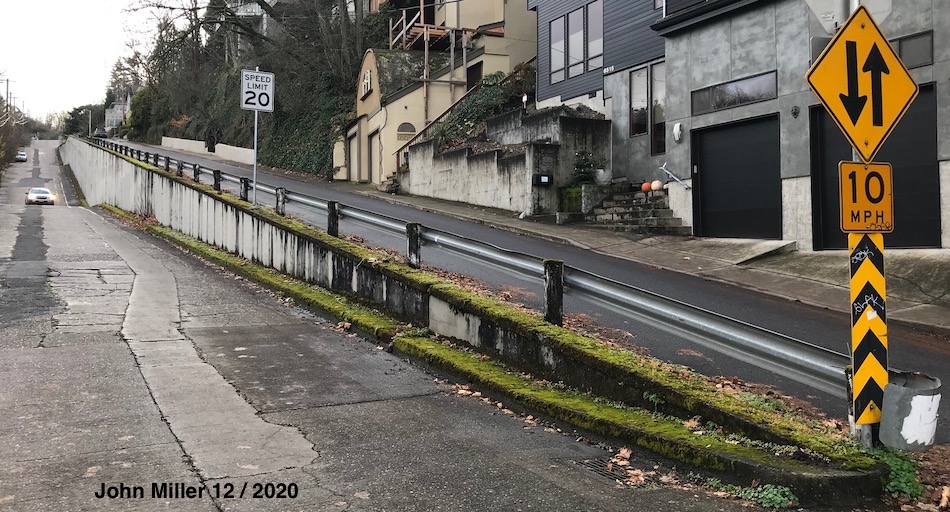
John's Landing is a flatland between the Willamette River and the base of the West Hills. Corbett Street runs straight north-south along the base of the hills. Near the south end of Corbett at Nebraska, the avenue is split into a ramp that goes up an incline (12.8% grade, or 7.3 degrees).

Was this used by the Trolley / Street car? No. This is folklore. The ramp is simply an artifact of a earlier large retaining wall, similar to smaller ones on this east slope of the West Hills, above and around Barbur blvd, more related to creating terraces of buildable lots, i.e Land == $$. The ramp/wall was constructed Long After the F Line ceased operation.
The Oregonian on May 12, 1912, page 9:
Improvements in Southport, under a district assessment petitioned for last Summer, cost more $50.000, and have transformed the district from a modern farm Into an attractive residence section. The first improvement was that of extending Corbett south from Dakota street to Fulton Park. To do this required the making of a heavy cut. Two separate roads were made, one for residences on the right hand (east) side of the street and the other (road) for those on the opposite side. One road is 30 feet above the other. They are divided by a heavy rock and concrete wall. These roads open up a means of travel between many residences of the Fulton Park district and Corbett street. The only means of travel from the Fulton Park district before was a roundabout road. (Fulton Park Blvd)
Vintage Portland shows the ramp as an unpaved trail next to SW Corbett Avenue in 1939. [LINK]

'JimW' on Vintage Portland commented: The wall dividing the grade separation was rebuilt in 1959.
Even though an electric trolley could have managed the steep slope, the F Line instead took a gradual route along the hillside, using trestles to cross ravines. Similarly, the N-S Line actually came out Corbett from Portland, and turned east here on Nebraska and stayed at the same basic elevation to get to the Town of Fulton and lower River View Cemetery.
Whereas we've worked hard to gather the information presented here; and we've added value with our original writing; we are placing this page under a Creative Commons Attribution 4.0 International license [CC BY-NC-SA 4.0].
All we ask is notification and attribution of any re-use. Please send notifications to trolley @ Dialectrix.com — Thank You!
The Trolley Project, Portland, Oregon.