The southern portion of the N-S Line was established in 1900 as a replacement for the Fulton-Park—Cemeteries (FP) Line. When the City & Suburban Railway took over the lease of the Metropolitan’s FP Line in 1897, they immediately began envisioning a different route to River View Cemetery. This company had been responsible for much of the electrification of the old horsecar routes, and they had more than forty miles of track on both sides of the river, so they put their experience — and possibly some of their old track hardware — to work.
One of the first things City & Suburban did was remove the powerhouse at Fulton Park and transfer the machinery to the new central power station on the east bank of the Willamette, which would ultimately power the N-S Line. Soon they were converting the FP Line’s downtown tracks south to Corbett from standard gauge to narrow, which meant that for the last couple of years of the FP Line’s life, passengers had to change cars at Abernethy Street.
At the end of 1899, after the city denied their request
to run the trolley from Corbett to Macadam and then to Taylors Ferry,
City & Suburban was granted a right of way on Nebraska, Virginia and Taylors Ferry Road.
Within the year, the FP Line ceased operation to Fulton Park and the cemeteries, City & Suburban had torn up its off-street tracks, and service had been extended past the Town of Fulton and perhaps up Taylors Ferry Road to River View Cemetery. (A 'Fulton extension' was completed in 1900, but we are not sure what 'extension' meant. Labbe p93.)
One of the first City & Suburban Standard cars on the North & South Portland line, which replaced the old Metropolitan line. Oregon Historical Society (Labbe p95.)
This so-called Fulton extension of the N-S Line was a scenic route popular with sightseers and cemetery visitors, but it was also a way for the growing population of South Portland to travel downtown for work and pleasure. Though the trolley ran lower on the hillside than the old FP line, the N-S Line also had some challenging hills, and runaway cars were a common sight in the increasingly built-up Johns Landing and Fulton areas.
N-S Line on Corbett, near Hamilton perhaps (RTPS P71)
The trolley ran until 1937 when service along the N-S Line was converted to trolley coach (trackless electric buses). A 1943 Trolley Map of Portland
[7.5 MB JPG]
shows a WA Line, then operated by Portland Traction Company, running from North Williams Avenue on the east side, across the Steel Bridge and along the N-S route to River View Cemetery. By the 1950s the entire Portland trolley system was gasoline powered. As automobiles became common, trolley and bus service to River View Cemetery was less necessary, and we presume that while the bus still turned around at the wide spot on Taylors Ferry, few if any people got off to visit the cemetery.
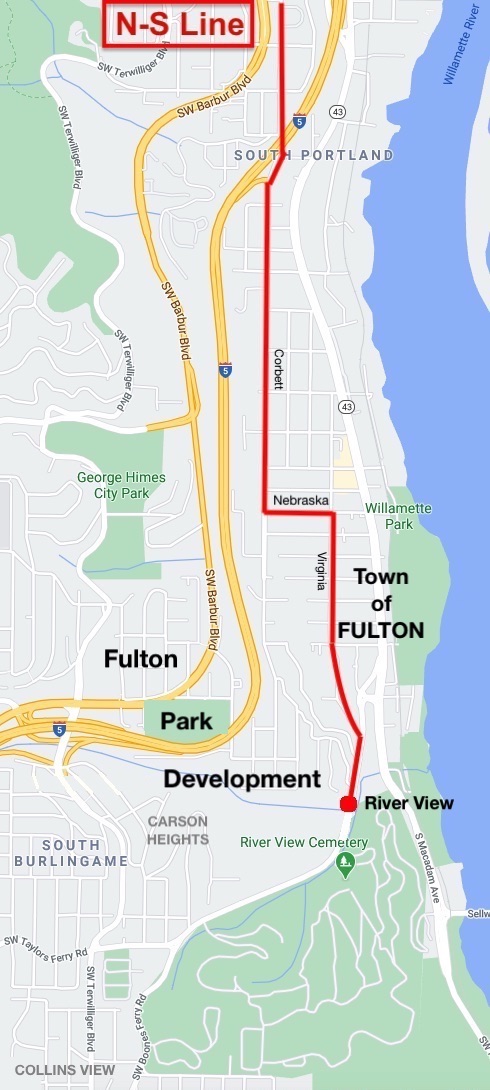
The N-S Line to River View Cemetery
The history of the N-S Line has been elusive, but because the trolley followed city streets, its route has been easier to trace than the FP Line’s. We also have the image of an undated N-S ticket showing the route from NW 24th and Nicolai to SW Taylors Ferry Road at some point in its history.
N-S Line Ticket, from page 19 of Richard Thompson's Portland's Streetcar Lines
In 1900, the N-S Line originated at NW 27th and Thurman, but in a few years the line was extended at the north end to Nicolai.
It headed south on (NW) 16th, then east on Glisan to Third Street.
The N-S line traveled through downtown along Third Street (now SW Third Ave).
Similar to the FP Line, the N-S trolley turned east on Grant Street and jogged over to Corbett Street, via Front and Gibbs.
It traveled south on Corbett for about a mile and a half, turning at the place where the street splits and heads steeply uphill today. (This 'Corbett Ramp' was not built for or used by the N-S line or any other trolley. See our discussion of the ramp in
Special Features.)
The trolley went east on Nebraska for two blocks, then south on Virginia.
At Taylors Ferry Road, it turned uphill for about 1/8 mile, past Fulton Park Blvd.
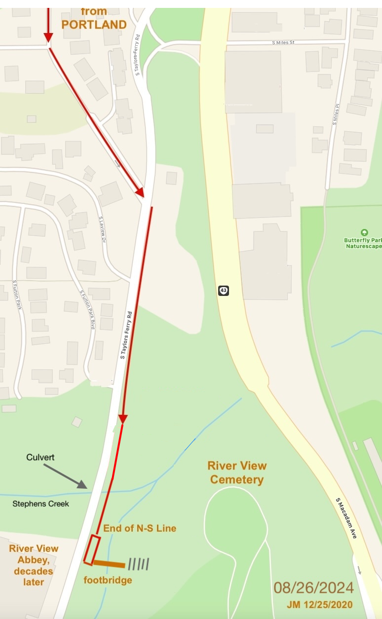
The end of the N-S line was at a wide spot along Taylors Ferry on River View Cemetery property, where the trolley pulled over to discharge and pick up passengers. (See next section.)
River View Cemetery line
At the Terminus of the N-S Line
People would get off the trolley and walk down a path to Stephens Creek, where they crossed a footbridge provided by River View Cemetery. They climbed a path on the other side up to a 20-step staircase onto a terrace in Section 1, one of the oldest parts of the cemetery just north of the modern-day chapel and offices.
We’ve been told by a retired River View employee that the footbridge was built by the cemetery, and that traces of it were still there in 1965 when he started work. Still visible is a rock wall associated with the path and bridge. The staircase, also provided by River View, will be on the Self-Guided Walking Tour, along with a view of the rock wall.
Also at the N-S terminus was a City & Suburban innovation — a telephone box, used by operators to report any problems, delays, or interruptions to the central switchboard. The various telephone dispatching boxes at the ends of trolley lines are indicated on the 1918 Track System map on the inside cover of Labbe’s book.
End of the N-S Line at River View Cemetery (for illustration purposes!)
There can be little doubt about this as shown by the following chart. (From S.D.)
End of the N-S Line at River View Cemetery
According to River View Cemetery board minutes, there was a two-track car barn and tool shed there, with a passenger shelter in this location, built by City & Suburban (in addition to the telephone box).
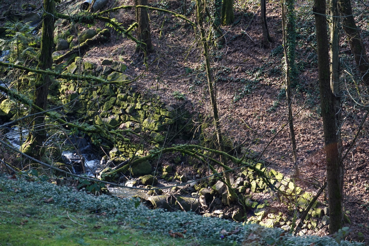
The Rock Wall
Photos taken from Section 06 of River View Cemetery looking toward Taylors Ferry Road. The rock wall along Stephens Creek was either the base of a path leading from the N-S Line terminus to a footbridge into the cemetery — or it could have held up the bridge — or both. We’re hoping to learn more once we access the River View archives and talk more with the retired RVC grounds manager.
Rock Wall below the terminus of the N-S Line
Another view of the Rock Wall below the terminus of the N-S Line
We figure that the wall was made using basalt blocks quarried from a conveniently exposed formation on the other side of Taylors Ferry Road, below Stephens Creek.
Modern Era: The Third Avenue Electric Trolley Bus
Portland in those days also had electric trolley buses traveling beneath overhead wires. They were quiet, clean and moved mostly over city streets except for the Third Avenue bus that hummed along Southwest Corbett Street to a turn-around on Taylors Ferry Road at Riverview (sic) Cemetery. The turn-around was a dark and lonely spot where drivers, catching a smoke, were often set upon by robbers hiding in the bushes. — Paul Pintarich, In My Time / Growing up in Pre-Suburbia, p 112.
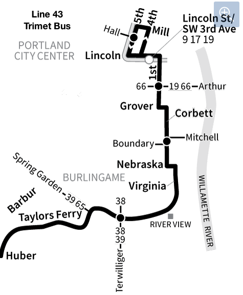
Modern Era: Line 43 Trimet
Until 2021, Line 43 Trimet bus came out from downtown on Corbett, turned on Nebraska and went along SW Virginia, just like the N-S Line trolley! It went up Taylors Ferry Road passing the old end-of-the-line for the N-S Line (Riverview) trolley. There were bus stops at River View Cemetery and River View Abbey on opposites sides of Taylors Ferry Road. The Trimet 43 Line then went to the top of the hill, and continued westward on Taylors Ferry and other roads all the way to Washington Square.
Line 43 was radically revised in 2023, no longer tracing the old Trolley (bus) line.
Trimet Line #43
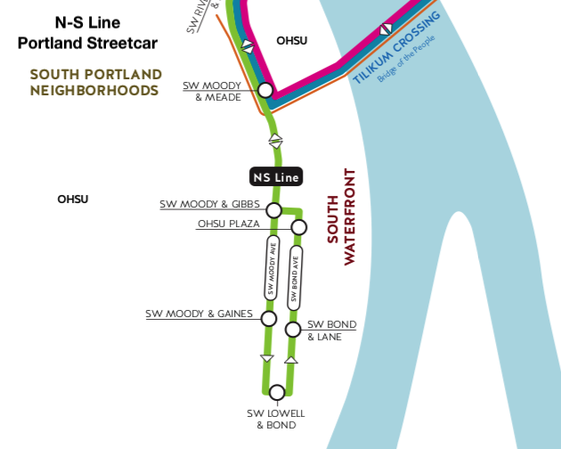
Modern Era: Portland Streetcar
Unrelated to the trolley line, The Portland Streetcar has an N-S Line! It runs north-south from NW Portland through downtown on 11th Ave, down Harrison Street, then down into Harbor Place and South Waterfront, stopping well short of John's Landing. It does not go to the cemetery!
Link to [PortlandStreetcar.org]
Southernmost loop of the Portland Streetcar N-S Line
Questions to Answer about the N-S Line!
When did the City & Suburban trolley first arrive in the town of Fulton?
When was Corbett Avenue extended beyond Slavin Road?
We can think of more!
Please Honor our Creative Commons License
Whereas
we've worked hard to gather the information presented here; and
we've added value with our original writing;
we are placing this page under a Creative Commons Attribution 4.0 International license
[CC BY-NC-SA 4.0].
All we ask is notification and attribution of any re-use.
Please send notifications to trolley @ Dialectrix.com — Thank You!