We became interested in the Oregon Electric interurban railway primarily because its well-documented route provided clues to the location of segments of the earlier Metropolitan Railway (1891-1899). While our research into the Oregon Electric, and its nearby cousin the Red Electric, has taken on a life of its own, this section doesn’t pretend to be a comprehensive history of the interurbans that served Southwest Portland. Instead, we hope the assembled facts and photos will shed light on our main focus — the Fulton Park (FP) and N-S lines — and the ways in which the interurbans continued and expanded electric rail service to the SW neighborhoods and cemeteries.
Oregon Electric Railway
The Oregon Electric Railway Company (OE) was incorporated in 1906 by a group of East Coast and local interests who planned to build an electric railroad from Portland downstate as far as Roseburg. They absorbed the Willamette Valley Traction Company, which had already begun construction in Salem for its own interurban to Portland but had been stymied by how to get across the Willamette River at Wilsonville and through the hills of Southwest Portland to downtown. The OE solved the Portland problem by using parts of the abandoned rights-of-way of the Metropolitan Railway and the City & West Portland Park line.
Construction continued from south to north while the OE strove to obtain franchises to Portland streets. In the meantime they built a 2,600-foot trestle across the Willamette River at Wilsonville, electrical substations at necessary intervals through the Willamette Valley, and a depot at the base of Jefferson Street downtown with a carbarn and shops a little farther south.
In January 1908, the 40-mile line between Portland and Salem opened for passengers, and a branch to Forest Grove started up at the end of that year. The line was extended to Eugene in 1912, but never to Roseburg. In 1910 railroad magnate James J. Hill added the OE to his Spokane, Portland & Seattle system, and because of this, the OE never had access to Union Depot, built by rival railroader E.H. Harriman, instead using the North Bank and Jefferson Street depots.
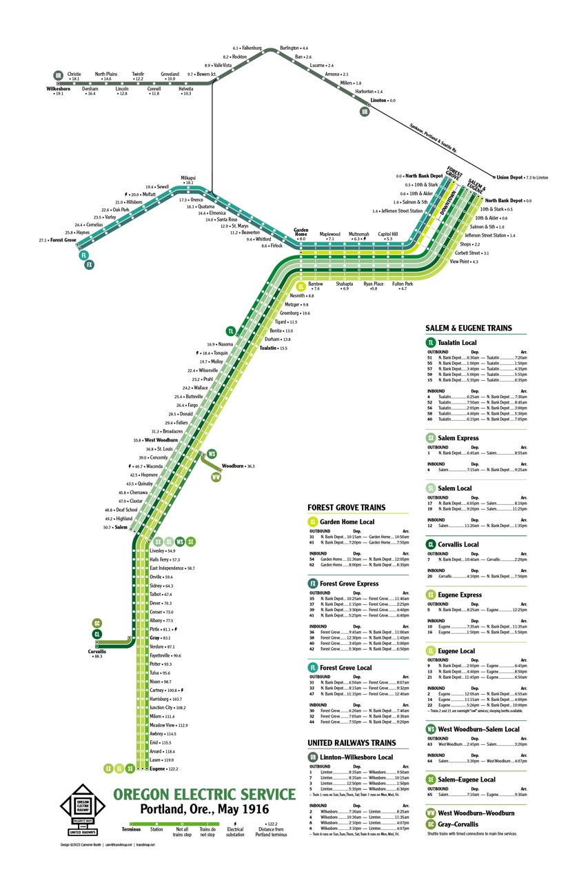
Thanks to Cameron Booth of Transit Maps, we have a modern view of the Oregon Electric as it existed in 1916. In his diagram we can see the two main branches with stops and mileages, as well as local and express schedules. Some smaller flag stops like Roland in the Burlingame area are not shown.
Map by Cameron Booth/Portland Streetcar History. For more detail, go to a zoomable version at [LINK]
The Oregon Electric was designed for heavy passenger and freight traffic, with standard gauge tracks built to railroad specifications. By 1924 the line was living up to its potential, with 24 passenger trains per day running through the SW Portland area, most destined for Salem, Eugene, or Forest Grove, but a half-dozen locals to Tigard or Tualatin.
Leaving downtown
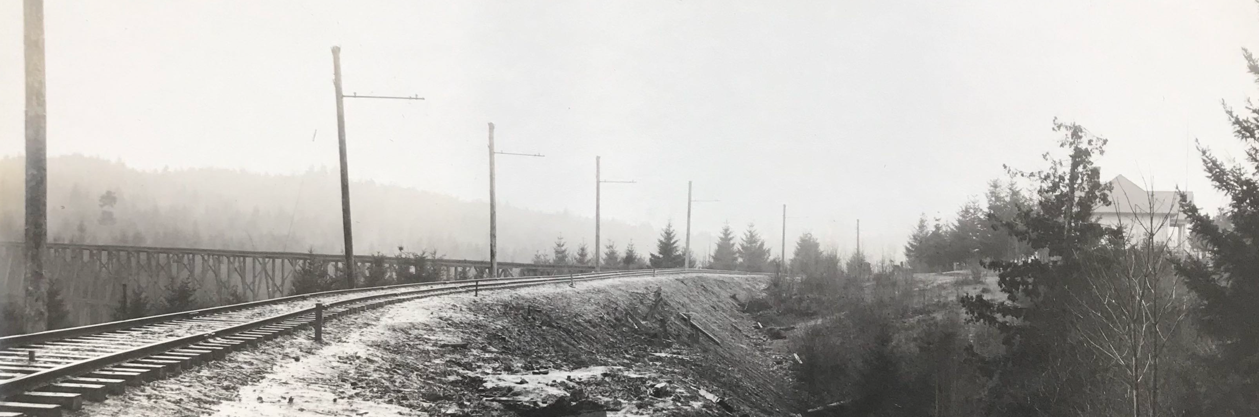
The section of the Metropolitan right-of-way used by the OE lay between the Corbett Street/Slavin Road crossing and Fulton Park, essentially where I-5 is now. From the new Jefferson Street station, the OE traveled to Corbett along what is now approximately SW Hood, following the contour of the hill, and crossing Corbett at grade. To accommodate the heavier trains, the OE needed to beef up any older trestles that still existed and, like both the FP and N-S lines, the OE had to cross the gulch south of Slavin Road on a trestle.
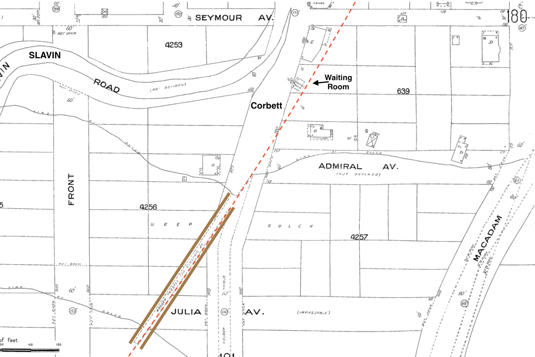
This Sanborn insurance map from 1909 shows the “wooden trestle” (marked in brown) that the OE built across the “deep gulch,” just southwest of the “waiting room.” The trestle branched off from Corbett, which itself continued over the gulch on a “wooden bridge” that would have carried wagons, carriages, the N-S trolley, and later automobiles into the growing South Portland area. For a photograph of the Corbett trestle and a discussion of how the OE and two trolley lines managed this crossing, see our Sidetracks page on the Corbett Gulch
[LINK]
“Wooden Trestle for Electric Ry”, as shown on a 1909 Sanborn Map, Sheet 179.
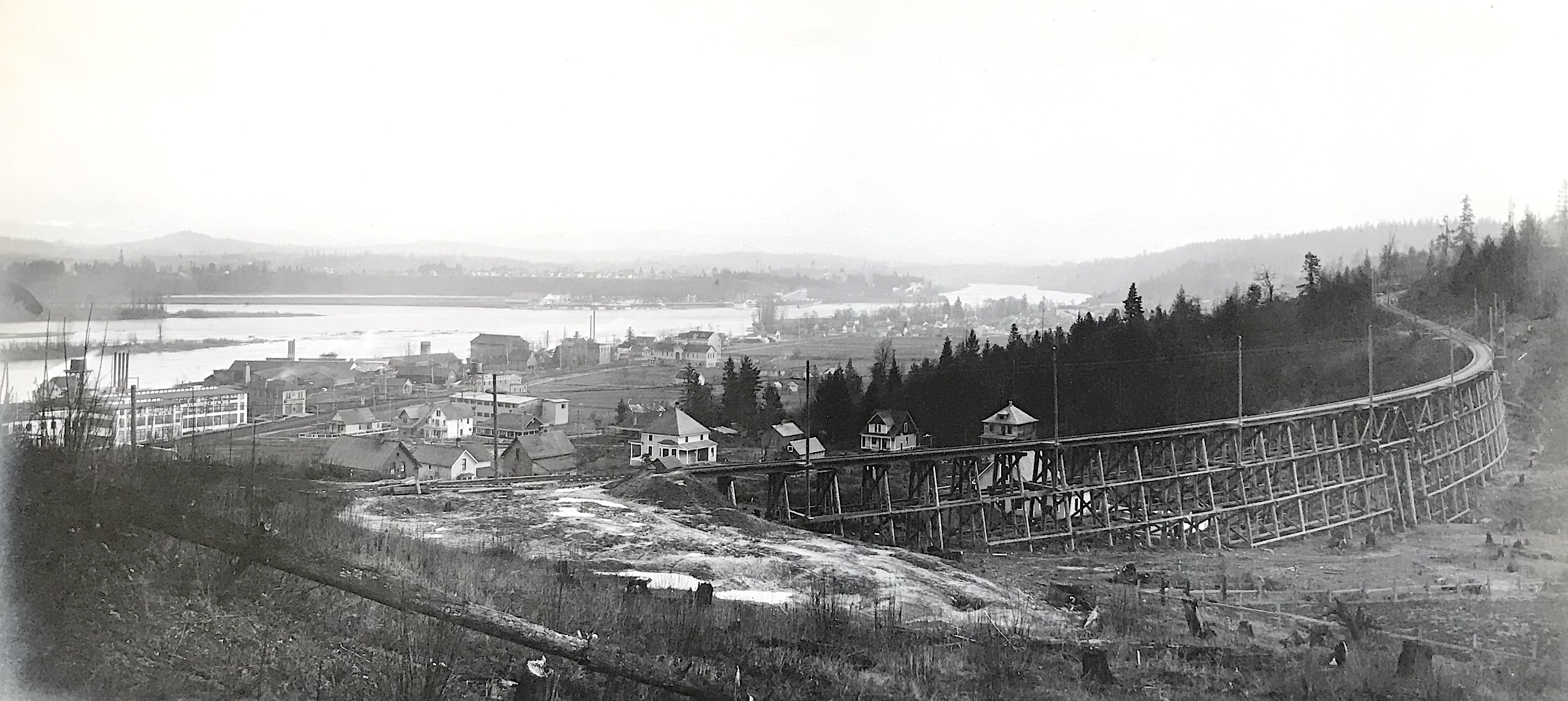
Farther south, a new trestle was built to replace the long curved FP Line trestle between current Richardson and Boundary streets. This striking photograph, taken around 1910, shows that trestle, with John’s Landing below and Oaks Park in the distance.
I-5 now occupies this section of the Oregon Electric, but several of the houses below the trestle still exist on Boundary Street and View Point Terrace. Photo by Fred Kiser, Oregon Historical Society (Album 278, ORHI 78582)
The Oregon Electric hired two photo studios — Fred Kiser and Angelus —to document the initial construction of the OE, as well as the later double-tracking, from Portland to Salem. The images they captured — invaluable views of trestles, unballasted tracks, and even mud slides* — are preserved in Album 278 at the Oregon Historical Society. We believe most of the photographs were made by Fred Kiser, and our credit lines reflect that until we know more.
* To learn more about the mud slides that plagued both the OE and the Metropolitan, see our Sidetracks page on the massive retaining wall that was visible along I-5 until 2010. [LINK]
On to Fulton Park and Burlingame
For its traverse of the hillside, the OE built new trestles over the Iowa and Vermont ravines where the FP Line had crossed, and where I-5 still does. (The Southern Pacific trestles were farther up the hillside.) Where the FP Line went straight south through the Brier Trench to Fulton Park, the OE followed the contour of the hill, making an arc south of Fulton Park and continuing through Burlingame. This area is in the I-5 alignment known as the Terwilliger Curves.
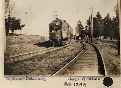
The OE rounds the curve at the southern edge of Fulton Park, where I-5 is now, with Custer Street to the right. Photo by James G. Harlow, in the David L. Stearns Collection at Oregon Historical Society (ORHI 101714)
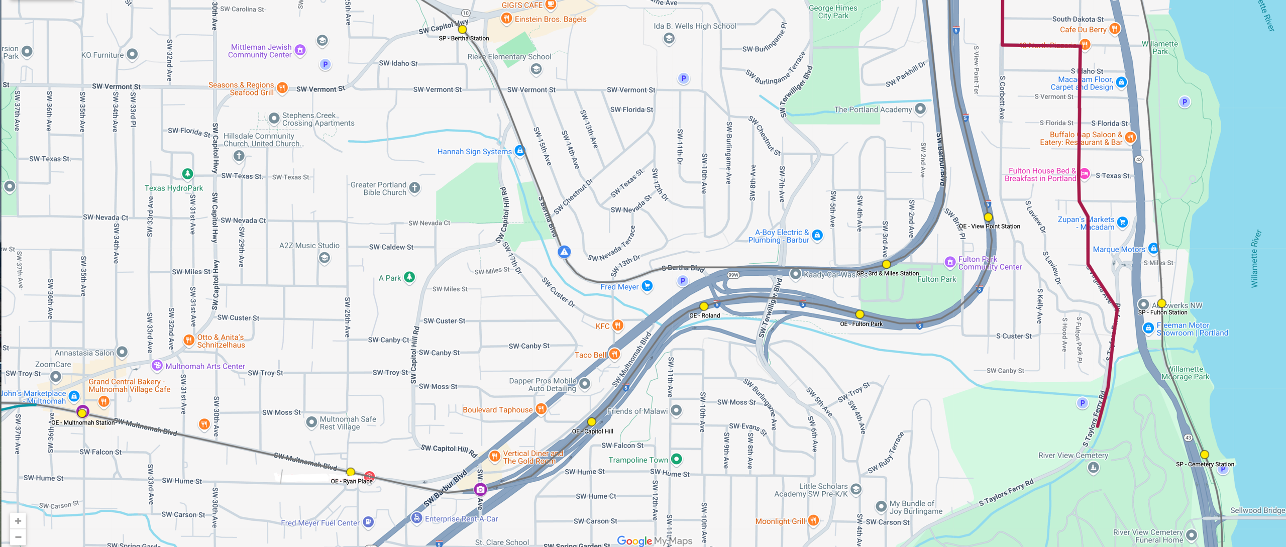
In the Burlingame area, the OE came within yards of the Southern Pacific steam line and later Red Electric before the latter curved away to Bertha/Hillsdale. From there, the OE headed south and west, joining part of the abandoned right-of-way of the City & West Portland Park line along what is now Multnomah Boulevard to Multnomah Village and Garden Home.
This detail from a Google Map of Portland streetcar lines created by Cameron Booth/Portland Streetcar History shows the SW area being discussed in our narrative.
The SP/Red Electric "west side” route can be seen on the Barbur and Bertha Boulevard alignments; the Oregon Electric where I-5 and Multnomah Boulevard are now; the N-S Line on Corbett and Virginia streets; and the SP/Red Electric "east side" along the river.
Interurban stops shown with yellow dots. For the full interactive map, go to
[LINK]
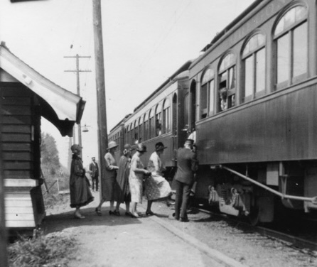
There were a few points along the OE’s route through Southwest Portland that may have served FP Line riders after that trolley stopped operating in 1899. From the View Point station, one could scramble down the hill to Corbett Avenue and Fulton Park Boulevard, where homes were springing up in response to a new water system, road improvements, and sidewalks. (The FP Line had been created in part to sell land in this Fulton Park area.) From View Point one could also catch the N-S Line on Corbett or Virginia or the SP-Red Electric south to River View Cemetery.
According to old Portland Schools documents, the recommended transit connection to Fulton Park School was the “Fulton car” on the N-S line, which involved a steep hike up the hill. An easier way might have been to ride the Oregon Electric to the nearby Fulton Park station at the same elevation, though the service was probably not as frequent.
In 1913, an ad in The Oregonian offered a suggestion for a “A Delightful Sunday Walk” involving both the N-S Line and the OE, with real estate as the unsurprising goal. It said, in part,
“Take a Fulton car to Riverview and follow the Taylors Ferry Road through Carson Heights, where lots are being sold for $500 in installments… Return by the Oregon Electric, and you will realize the many desirable features of this delightful district.”
— Sunday Oregonian, 12/7/1913, p. 9
It’s interesting to speculate whether pedestrians might have used the old Metropolitan trestle to cross Stephens Creek between the OE Fulton Park stop and Carson Heights. The FP Line had stopped running about ten years before the OE arrived, but the trestle coexisted with the OE for some unknown period of time (see photo below). And since City Council had appropriated $75 to have sidewalks installed in 1895 (Oregonian, April 4, 1895), it’s conceivable that pedestrians continued to use it.
This detail of a photo taken when the OE was still new shows a filled area just before the OE’s Fulton Park station, with the retired Metropolitan trestle taking off across Stephens Creek at the left and the first Fulton Park School at the right. Photo by Fred Kiser, Oregon Historical Society (Album 278, ORHI 78593)
Roland Bridge
Another way to Carson Heights and possibly the cemeteries would have been to get off the OE at the Roland flag stop and cross the Stephens Creek gulch on the now-forgotten Roland Bridge, near Fred Meyer Burlingame and Bertha Boulevard in the 10th Street alignment. The name Roland was chosen for the stop to honor a local family that had settled in the area. Roland was also the name of a proposed street and development wedged between the OE and the Red Electric at their closest point. There’s no evidence the Roland Street Addition was ever developed.
In the 1920s, Donald Burkhart, a young local photographer who grew up near the Capitol Hill station, seemed as fascinated with the Oregon Electric as we have been, and took several iconic photographs of the train and its tracks through our area. This is his shot of the Roland station and bridge, taken in 1928 from atop the new “Burlingame auto bridge,” aka Terwilliger Bridge. Though not visible, the Red Electric would have run on the hillside above the OE tracks and curved northwest at the notch, where Fred Meyer is now.
Looking southwest at an Oregon Electric train passing by the Roland station, with Capitol Hill in the distance.
The Roland Bridge was the only way for pedestrians and presumably automobiles to cross Stephens Creek until the Terwilliger Bridge was built farther east in 1928.
(For more about the bridges that crossed Stephens Creek through the decades, see
The New Collins View Blog.)
Photo by Don Burkhart, Oregon Historical Society (DB 316) as scanned from the Richard Parks/Walt Ainsworth collections, courtesy of Sheldon Perry.
Beyond Burlingame
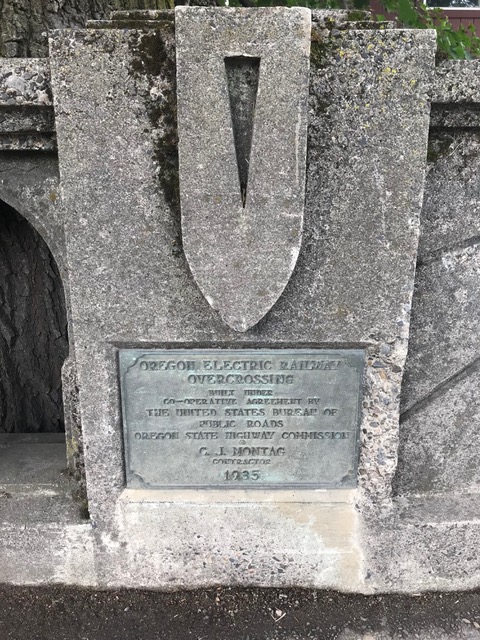
The next stop for the Oregon Electric was Capitol Hill, which served a developing neighborhood on both the north and south sides of the tracks. Just beyond there, the OE entered (and enlarged) a cut made earlier by the City & West Portland Park Railway. Little-seen plaques on the Barbur Boulevard bridge built over the OE tracks in 1935 salute the OE’s right-of-way beneath, where the Multnomah Boulevard exit from I-5 is now. Passenger service had ceased by the time Barbur went in, but freight trains were still passing through.
A bridge on SW Barbur Boulevard over Multnomah Boulevard bears two plaques that read: Oregon Electric Railway Overcrossing, Built Under Co-operative Agreement by the United State Bureau of Public Roads, Oregon State Highway Commission, C. J. Montag, Contractor, 1935. Photo by CD Stowell.
As the OE continued along what is now Multnomah Boulevard, it came to the Ryan Place station, near today’s SW 25th, named for the family that had settled in the area, which was platted in 1908.
Ladies boarding an inbound Oregon Electric at Ryan Place in 1926. Note the Craftsman-style station shelter, the most handsome of several styles built along the OE line. Photo by Don Burkhart, Oregon Historical Society, DB 23, scanned from Richard Parks/Walt Ainsworth collections, courtesy of Sheldon Perry.
Multnomah and Maplewood
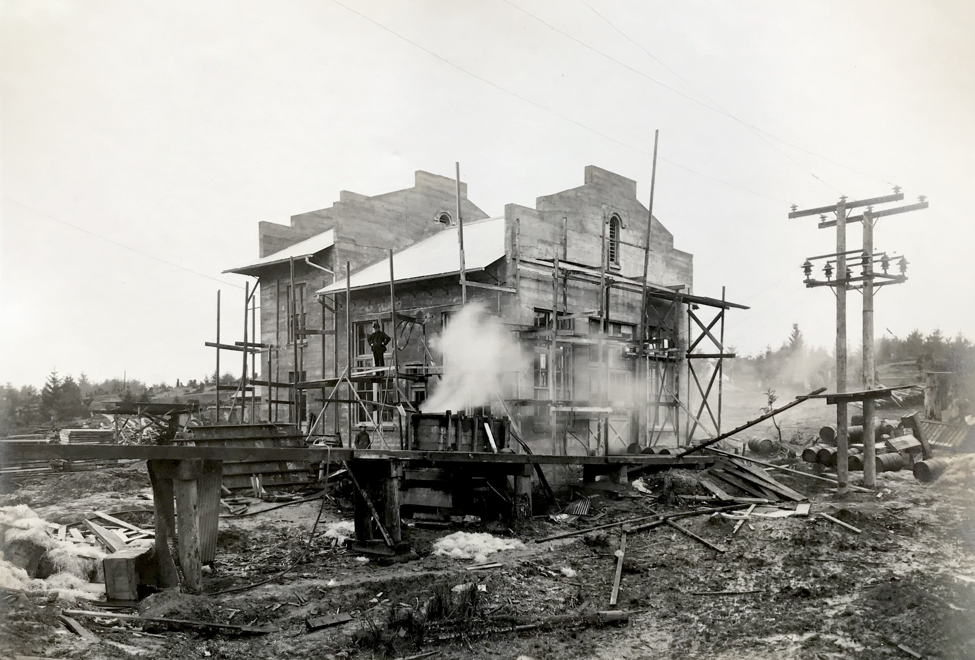
A great example of “transit-oriented development” is the community of Multnomah. When the OE arrived in 1908, the area was populated mostly by dairy farmers and only the new ticket office and electrical substation were there to greet the trains at “Multnomah Station”, so named by the Oregon Electric. But the interurban was a catalyst for development of the commercial area along Capitol Highway uphill from the tracks. In this Fred Kiser photograph of the concrete Multnomah substation under construction in about 1907, it’s clear that the OE’s facilities were the first to arrive in what would become a bustling commercial district.
The massive Multnomah power substation was all by itself until the community grew up around it. Few if any people remember the substation, with later photos showing only the adjoining wooden ticket office, but both existed into the 1930s at the corner of SW Multnomah Boulevard and 35th, where John’s Marketplace is now. Photo by Fred Kiser, Oregon Historical Society (Album 278, ORHI 78605)
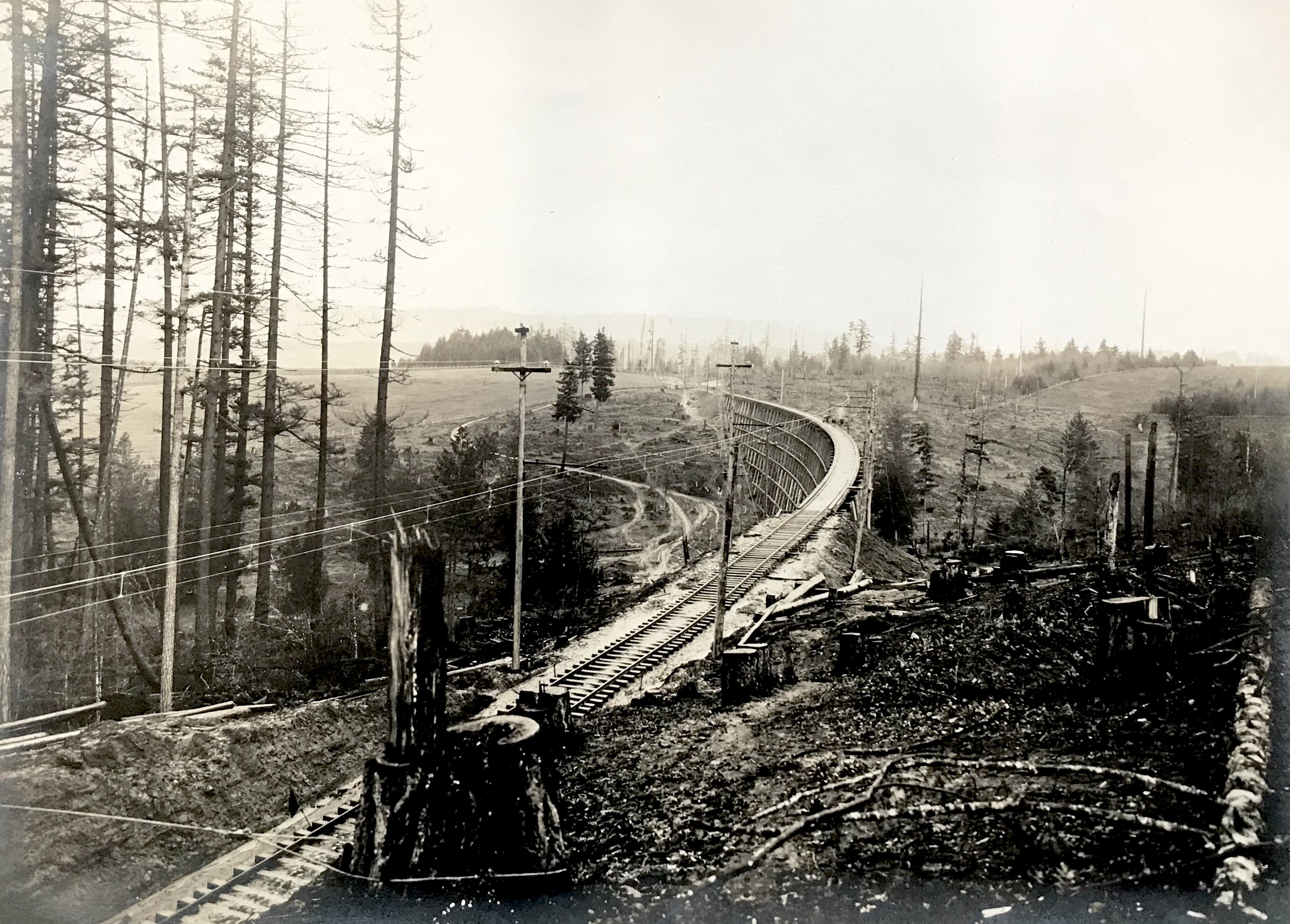
After Multnomah, OE trains made a catenary curve through Maplewood, passed over an impressive trestle, and came to Garden Home, where the tracks divided between the Forest Grove route to the right and the Salem route to the left. The Maplewood curve and trestle were eliminated in 1914 in favor of a straighter track, which involved engineering a huge cut and fill that can still be seen along Multnomah Boulevard past 45th. The former curve remains as Maplewood Avenue.
Looking north at the Maplewood trestle during construction, ~1907, showing the tree removal and earth moving that was necessary to get tracks across the rugged terrain of the southwest area. Photo by Fred Kiser, Oregon Historical Society (Album 278, ORHI 78602)
Riding in Style
A handful of older SW Portland residents remember (or more likely heard their parents talk about) riding the elegant Oregon Electric cars, either to go downtown for shopping or work, or to venture south to the college towns. The cars were handsome and well-appointed, finished inside with mahogany and silk, with sleeping cars on some runs, as well as the famous observation/parlor cars with awnings and outdoor seating. It would have been a definite upgrade from the Metropolitan’s more spartan and sometimes open cars!
The OE’s parlor cars, like the “Sacajawea” above, afforded an elegant and scenic way to view the Willamette Valley from the rear of the trains. (Photo from Warren Wing Collection, via pdxhistory.com)
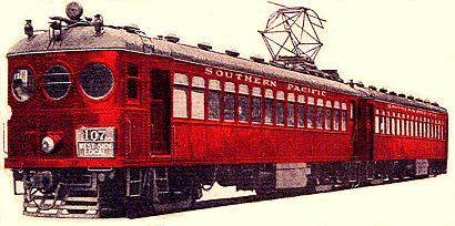
Southern Pacific’s Red Electric
Less relevant to our studies, but even more lodged in the collective memory, was the Southern Pacific’s Red Electric interurban, which began service in 1914. When SP owner E.H. Harriman saw the popularity of rival James Hill’s Oregon Electric, the company decided to convert their own Willamette Valley steam lines to electric. But the SP’s ambitious plans for service to Eugene were quickly scaled back to a short but popular route through the upper Willamette and Tualatin and Yamhill valleys.
The “west side” section left Union Station in Portland and went out Fourth Street (now Barbur Boulevard), turning west at Burlingame to Beaverton and Forest Grove, then south to McMinnville. The “east side” line went straight south from downtown along the Willamette River to Oswego, then southwest through Newberg to McMinnville, with expansion to Corvallis a few years later.
The bright red color of the Red Electric cars, which gave the line its nickname, along with its three circular windows at the front, made the line appealing and memorable to local residents.
Just say the word “trolley” and people in SW Portland will launch into stories about the Red Electric, the best remembered of all the trains that visited the area. Top of mind is the tragic wreck that happened in 1920 just south of Hillsdale and northwest of the current Fred Meyer Burlingame. The head-on collision of inbound and outbound trains, caused by the inbound engineer’s failure to wait for the outbound train to pull over onto the siding along current Bertha Boulevard, resulted in nine fatalities.
In part because of safety improvements like block signals, local Red Electric riders remained loyal through the 1920s.
The line was yet another way for SW residents to get downtown to work or shop, or to go downstate for college or games. The stop at Third and Miles would have been handy for teachers at the Fulton Park School or families eyeing property in the once sprawling Fulton Park development that was being replatted into smaller neighborhoods. The Red Electric also served the growing Capitol Hill and Bertha/Hillsdale residential areas.
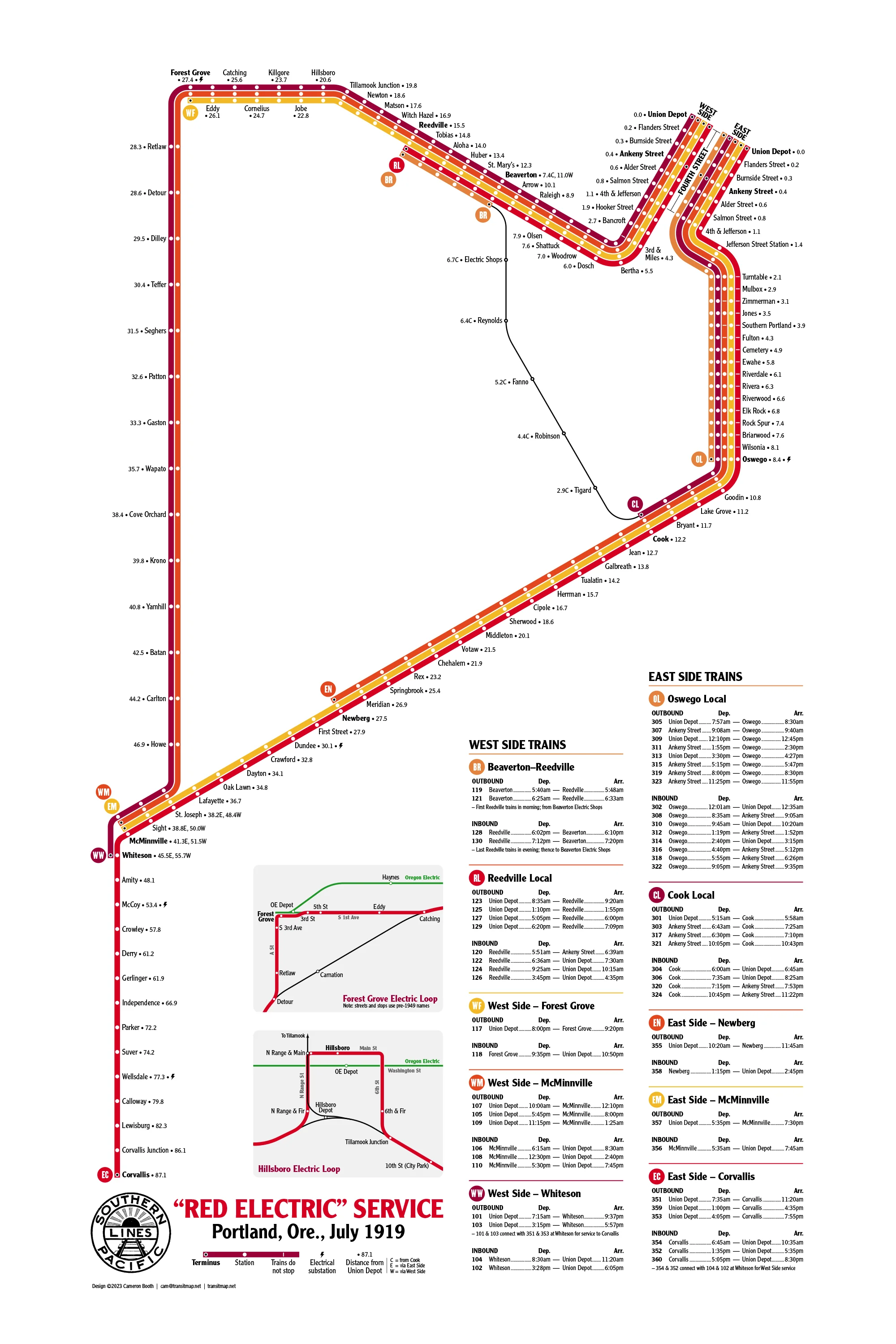
This Cameron Booth creation is a modern diagram of the Southern Pacific’s Red Electric route in 1919, showing how the west and east side branches made a loop from Portland through McMinnville, with continuation south to Corvallis.
Map by Cameron Booth/Portland Streetcar History. For more detail, go to a zoomable version at [LINK]
"East Side" Line
The scenic “east side” line, which ran south next to Macadam Avenue, was one way for people to visit River View Cemetery. They could get off at the Cemetery stop, between Taylors Ferry Road and the Sellwood ferry (and later bridge), with easy access to the cemetery gatehouse but a climb uphill to the burial areas.
The Red Electrics continued south from there, serving the wealthy communities growing up along the river. This section was probably best known for the Elk Rock Trestle, which clung somewhat precariously to the base of a cliff, where trains were often pelted with falling rocks. That trestle was replace by a tunnel in 1921.
The photograph below features a different Southern Pacific trestle, at the Riverdale station before electrification. Likely taken before 1900, the photo also captures a moment in time when several landmarks coexisted: the turreted Palatine pumping station at the south end of the trestle; the Riverside Hotel (aka White House), on the north-facing side of the peninsula, where a popular inn, tavern, and racetrack did business next to the ferry to Milwaukie; and a steamboat that still provided an alternative to land routes.
From Stations West, by Edwin Culp
The End of the Interurbans
The Oregon Electric and Red Electric were competitors for Willamette Valley riders, though students and the sports-minded sorted themselves out based on the final destinations of the lines: University of Oregon Ducks fans rode the OE to Eugene, and the Oregon Agricultural College (now Oregon State University) Beavers fans rode the Red Electric to Corvallis.
But the arrival of the automobile cut into ridership on the two lines,
with OE traffic through Portland tapering to 14 in 1931 and a single train in 1932, while many Red Electric trains were being replaced by “Silver Gray” buses resulting in electric cars being sold off in the late 1920s.
The Red Electric quietly stopped service on both the west and east side lines in 1929, while the OE hung on until 1933, when the line became freight-only and abandoned its route through SW Portland.
Today, Barbur and Bertha boulevards have replaced the main Red Electric tracks through SW Portland, and a walking and biking trail is being planned to retrace the right-of-way. The Willamette Shore Trolley, an excursion train between Lake Oswego and South Portland, runs on the old SP east side right-of-way. The Oregon Electric route through SW neighborhoods can only be imagined while traveling on I-5, Multnomah Boulevard, and Maplewood Avenue, with a few berms visible in people’s backyards in Garden Home and Metzger, if you know where to look.
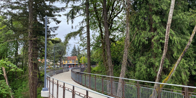
SW Trails and the City of Portland are working on a trail to not only commemorate the route of the Red Electric through SW neighborhoods but also provide a new transportation option between Garden Home and downtown Portland. This bridge has already been built in Hillsdale, and while not exactly the route the trains took along Bertha Boulevard, it gets bikes and pedestrians safely across a ravine, away from traffic, for a beautiful start to the Red Electric Trail. (Photo from Portland Parks & Recreation website)
Oregon Historical Society’s Album 278 contains invaluable photographs of the early years of the Oregon Electric, including the work of both Fred Kiser and Angelus Studio. We believe most of the images are Fred Kiser’s, but have yet to sort out the two studios’ contributions. The dates 1903-08 are also suspect because several photos may have been taken after the OE started running in 1908.
[LINK]
Books and Articles
Walter R. Grande, The Northwest’s Own Railway, Vol. II, 1997.
Tom Dill and Walter R. Grande, The Red Electrics, 1994.
Ed Austin and Tom Dill, SP&S, The Spokane, Portland & Seattle Railway, 1996.
John T. Gaertner, The North Bank Road, The Spokane, Portland & Seattle Railway, 1990.
TNOR, Official Publication of the Spokane, Portland & Seattle Railway Historical Society, Fall 2022 (articles about the Oregon Electric substations, operators’ cottages, and shelter stations.)
Lowell Swanson, Multnomah Historical Association, Oregon Electric Railway and Early Interurban Railways in Southwest Portland, Winter 2005 newsletter.
Please Honor our Creative Commons License
Whereas
we've worked hard to gather the information presented here; and
we've added value with our original writing;
we are placing this page under a Creative Commons Attribution 4.0 International license
[CC BY-NC-SA 4.0].
All we ask is notification and attribution of any re-use.
Please send notifications to trolley @ Dialectrix.com — Thank You!

.png)
.jpg)